TAPAS.network | 8 January 2026 | Commentary | Caroline Broughton-Smith
Could FUSION concept be the key to a new era of detailed travel data insight for transport planning?

In a pioneering travel data collection project, a single travel-tracking app used by hundreds of people recorded more than two million individual journey legs over a six months period revealing detailed travel insights never seen before in the UK. explains the potential implications of the latest research into digital data capture for the transport planning sector.
THE DEPARTMENT FOR TRANSPORT’S (DfT) FUSION project delivered by SYSTRA with partners TravelAi and Yonder Data Solutions (YDS), and reported in LTT926 12th November 2025 in December, marks one of the most ambitious advances in travel behaviour research the UK has seen in decades. At its heart lies a pressing national challenge: how can transport planners and policymakers make informed decisions without reliable, up to date real-world travel data?
In an era shaped by the rise of micromobility, fragmented multimodal travel and hybrid working patterns, the limitations of traditional data collection methods have become increasingly apparent and are now showing their age.
The FUSION project was conceived to break this data deadlock. It was prompted by a growing demand for accurate data on individual travel behaviour, a need that has been intensified by rapid changes in mobility patterns and compounded by the complexity of urban transport systems. Today, planners must grapple with a world where journeys are more varied, multimodal, flexible, and digitally facilitated than ever before.
Traditional data sources, including self-reported travel diaries and roadside traffic counts, lack detail and miss key elements such as precise timings, mode changes, and micro-movements. These methods often rely on an individual’s memory and also their compliance. Moreover, these surveys are typically conducted annually or even less frequently, making them slow to detect behavioural changes and slow to produce results.
The scale of the challenge is significant. Policymakers and planners need detailed, up-to-date insight into how millions of people throughout the UK choose (and change) their travel modes, routes, and patterns. Without this evidence, planning for transport modes, whether bus, rail, road, cycle or walk, can be guesswork. Therefore, the goal of FUSION was to develop a new approach to enable more precise and timely data collection and to enable evidence-based policymaking.
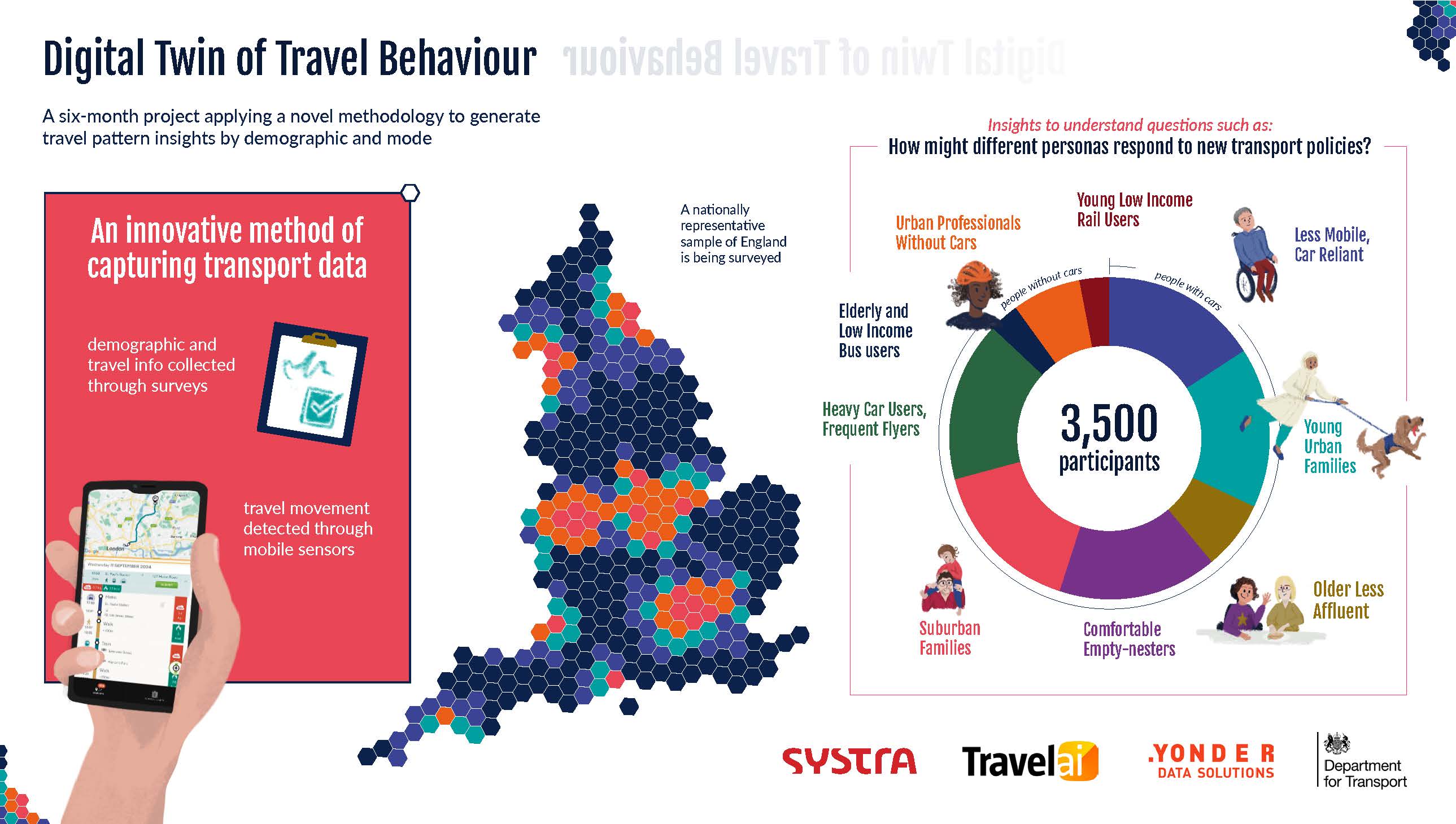
The project piloted a new, robust and ethically compliant method by integrating two data sources: large volume smartphone-sensor derived ‘big data’ captured through the MyWays app, with ‘deep data’ captured through online surveys collecting socio-demographic information and insights into why people travel, not just where, when, and how.
Together these sources create a new, high volume, representation of travel behaviour which fuses observed patterns with behavioural insights. The intention was not to replace the National Travel Survey and traditional methods, but to future-proof, modernise, and augment them.
Crucially, the work was designed around privacy principles, ensuring that all data used was aggregated, anonymised, and compliant with strict Government standards. No individual’s identity or personal movements were visible, instead only meaningful patterns.
Striking insights
The project demonstrates how transport professional practice can evolve from being based on occasional, specific survey-dependent insights into capturing more dynamic real-world travel behaviour understanding , capable of supplying practitioners and policymakers with an ongoing, reliable evidence base.
There were several striking insights. First, the sheer volume of movement captured; the users of TravelAi’s MyWays app recorded an enormous 2.1 million journey legs in just six months, demonstrating the power of passive data collection to reveal patterns that conventional surveys routinely miss.
Multimodal trips emerged far more frequently than expected, with walking, cycling, and public transport commonly combined within a single journey, showing how fluid travel behaviour really is.
Clear differences also appeared across transport user segments, with distinct groups showing markedly different patterns and needs, reinforcing the value of segment-based analysis for more inclusive policy development.
User engagement was unexpectedly high, despite no incentives to check or edit records. Almost 45% of journey legs were actively verified by the MyWays app users involved, and the high number of times the app was opened suggested strong participation.
Finally, the richness of the dataset enabled detailed comparison analysis, revealing how behaviours shift for each demographic group, for example during extreme weather events or after policy interventions.
Big implications for transport planning
Better data can lead directly to better decisions. FUSION’s approach has big implications for transport policy and planning.
For public transport, real-world insight into transfer times, dwell times, and multimodal journeys can improve service design and target resources to busy periods or specific demographic groups.
For active travel, richer evidence on walking and cycling patterns supports more targeted, high-impact investments.
Strategies to tackle city centre decarbonisation will meanwhile benefit from a clearer understanding of when and why people choose cars over less carbon intensive modes.
For road safety, granular movement data can identify risk hotspots missed by conventional collision records. Furthermore, regional authorities will gain access to powerful datasets to integrate land use and transport planning.
The FUSION approach does not claim to have solved every challenge in transport data collection and analysis; however, it does provide a great foundation. It demonstrates that we can move beyond traditional data collection tools that no longer capture the complexity of modern society, generating real-world data which provides ongoing insight into how travel behaviours are adapted in response to a changing world. It also proves that emerging data sources, when used responsibly, can revolutionise the evidence base underlying national transport policy.
In short, FUSION shows that it is possible for policymakers to understand mobility patterns closer to real time where evidence drives investment and where data finally reflects the full diversity of how people really travel. This new approach of fusing the where, when and how with the why, and with demographic information, allows specific policy and evaluation needs to be targeted which can lead to more inclusive transport policy.
The release of the FUSION report marks the end of the research phase. The challenge now is implementation and investment. With the framework in place, the next step is scaling the approach to support data driven decision-making across the UK’s transport landscape.
The FUSION PROJECT: SUMMARY REPORT delivered by SYSTRA for the Department for Transport can be found here using this link.
MyWays app link: https://www.travelai.info/
Caroline Broughton-Smith is Principal Spatial Data Scientist at SYSTRA UK & Ireland and a Geospatial lead for the consultancy side of SYSTRA, positioned within the Data Science Team.
[PANEL]
What is the My Ways app, and who are TravelAi?
FUSION project core data provider TravelAi, was set up in 2012 by co-founders: Andreas Zachariah (CEO) and Peter Lindgren (COO). It has built a system that provides continuous travel data extracted from users’ smartphones with software that runs in the background on mobile phones to detect the mode of transport that someone is using and their route, without requiring any interaction from them.
The system is now regularly used by thousands of people, 3500 of which were signed up to share their data for the project. The tool uses algorithms to study the speed, location and pattern of the users’ movement to identify their mode of transport. “We gathered millions of miles of journeys which we’ve used to train those algorithms, with the result that we can tell whether someone is travelling by train, bike, foot, car, bus, metro or air,” said Lindgren. Whilst it was intended for a third party developer to easily incorporate the code into their app, Travel Ai’s own MyWays app has been the mechanism to unlock the data used for the FUSION project.
Transport journeys have become increasingly complex and integrated, Lindgren, has observed. “Yet transport data is fragmented and trapped within silos of a particular mode, network, region or even fixed point on the road. We view transport from the customer’s point of view - revealing how they traverse modes, networks and regions. This breaks down the structural, commercial and incompatibility silos that often prevent organisations from linking their dataset on bus customers to that on train customers.”
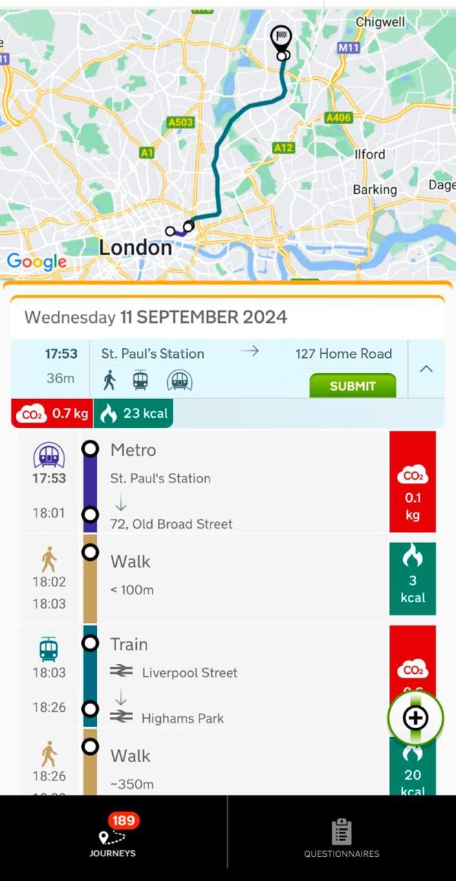
How the MyWays app displays the user’s journey
The MyWays app now both records users’ journeys and delivers questionnaires related to their travel. Customers see their journey history and have the opportunity to make their views heard to those in a psition to make changes to the transport system.
It automatically creates a journal of the user’s travel, including route and mode of transport, without them having to enter any information, and presents them with questionnaires relevant to their. TravelAi collates the travel patterns and questionnaire responses from the entire MyWays community so it “can help transport operators and local authorities make transport better.”
MyWays is claimed to correctly identify over 80% of journeys, and users can easily edit the travel journal to make it even more accurate. The app cannot yet detect the difference between car and motorbike journeys, though it encourages users to edit them accordingly.
Begun with a B2B launch followed by consumer launch in 2014 , supported by development seed funding, TravelAi worked early on with Newcastle City Council on a Department for Transport project to track cycling behaviour, with the subsequent 12-strong Catch! consortium including Ipswich Borough Council inviting parents and school pupils to download the Catch! app to understand home-to-school travel patterns.
The company based in Battersea, London claims to be the first to have automatically detected travel mode with smartphones, and to automatically carbon footprint a persons mobility choices. It says its vision is of a future where data about travel behaviour doesn’t just come from tiny samples of a few thousand volunteers, or from the involuntary data that cellular networks harvest from mobile users as they move around.
“Instead we see a rich, user consented data capture universe to help make transport systems better instead of location based advertising and other such low value services that compromise people’s privacy,” the company says describing it as “Crowdsource community intelligence without compromising individual privacy and always provide a direct benefit to the individuals that run our software using data to bring about change that makes journeys better.“
Travel Ai claims to use transport technology to make life more enjoyable, and help address huge challenges such as improving the nation’s transport system.
“Our mission is to provide effortless and accurate journey-detection tools that automatically sense and combine the travel intelligence of our community, working across the many transport horizontals to tell the true multi-modal and even multi-country mobility choices that everyday citizens make. From driving to cycling, the full gamut of public transit and even flying.”
TravelAi’s technology has been supported by the UK government and is already being used in the UK, France, Germany, Netherlands, Spain and Switzerland. It is designed to work wherever anywhere in the world as long as users have a data or WiFi connection and will detect flights even if the phone is turned off in the aircraft. If turned off on other modes , the app will still attempt to figure out the travel activity , but may not be as accurate. Users must enable GPS on their phone to allow the app to detect travel as it uses GPS intermittently.
Users must allow access to their location so that the app can create a travel diary, send notifications about questionnaires to complete, access the phone’s storage so it can record the travel data on the phone or memory card, and manage battery use.
MyWays uses industry-standard technology TLS to encrypt data as it is transmitted from a users phone , TravelAi says “The app transmits the journey data only a few times a day. MyWays is fully committed to compliance with the General Data Protection Regulations (GDPR).”
About Yonder Data Solutions
The other partner in the FUSION project, Yonder Data Solutions, is a UK-based market research, fieldwork, and data collection agency (formerly Populus Data Solutions). It provides high-quality data capture and analytics services for public and private sector clients utilizing advanced methods such as AI, video feedback, and biometric data collection. The business was formed as part of the Yonder consultancy, which launched in 2020 by combining Populus Data Solutions, BrandCap, and Decidedly.
About the data used
The FUSION project combined mobile phone data from the MyWays app and surveys to analyse transport usage across demographics over time.
The acronym is derived from ‘Fusion of User Surveys and Integrated Online Navigation’, the full title of the research project that SYSTRA led for the Department for Transport (DfT) in partnership with TravelAi and Yonder Data Solutions.
The FUSION project is designed to support analysis, transport modelling, policy evaluation and strategy development. It is funded by the Treasury’s Economic Data Innovation Fund (EDIF).
Approximately 3,500 participants completed online surveys and downloaded the My Ways mobile app that tracked their transport use within the UK over 6 months. These surveys collected information about participants, including:
-
demographics, including transport user persona types (see panel right)
-
travel use and preferences
-
time-use diaries
The FUSION Travel Survey and Movement Data comes from two open datasets: that from the MyWays app, and that specifically commissioned from 6 online surveys over an approximately six-month period.
Together the datasets contain anonymised, aggregated travel information based on around 970,000 routes comprising approximately 2 million journey legs, aggregated by region and transport user segment, age group, and urban/rural classification, along with a web analysis tool that offers map and chart visualisations of trips captured, including origin-destination (OD) trips where available.
The following definitions are used
Legs: A continuous movement using a single type of transport.
Routes: A sequence of legs (multi-modal travels) forming a complete trip between two places.
Segments: A higher-level grouping of routes, typically representing a user’s daily travel.
Anonymised and aggregated versions of the dataset, alongside survey questionnaires and the code for an analysis dashboard, are available through the EPSRC Geographic Data Service, part of Smart Data Research UK and based at UCL, the University of Liverpool, the University of Oxford and the University of Edinburgh.
DfT’s Twelve Transport Personas tracked
The FUSION data research used the Department for Transport’s 12 transport user personas, developed in 2022 with the characteristics validated with large-scale surveys.
The personas represent 9 different segments of people aged 16 and over in England, based on their demographic, attitudinal, and behavioural traits.
The DfT personas cover various demographics and transport behaviours, including individuals who are less mobile and car-reliant; young urban families; older and less affluent individuals; comfortable empty-nesters; suburban families; heavy car users who are frequent flyers; elderly and low-income individuals without cars; urban professionals without a car, and young, low-income individuals without a car.
These personas are described by the DfT as a tool “to help it and partner organizations ensure the transport system meets a wide range of user needs and to inform policy and decision-making”.
Full details and more information on the methodology used to create the personas can be found in a technical report available on the GOV.UK transport user personas page.
Caroline Broughton-Smith is Principal Spatial Data Scientist at SYSTRA UK & Ireland and a Geospatial lead for the consultancy side of SYSTRA, positioned within the Data Science Team.
This article was first published in LTT magazine, LTT928, 8 January 2026.
You are currently viewing this page as TAPAS Taster user.
To read and make comments on this article you need to register for free as TAPAS Select user and log in.
Log in