TAPAS.network | 15 October 2025 | Expert View | James Williams and Paul Curtis
Supporting Vision-led Development Planning with a place-specific Transport Planning Tool

The New Towns Taskforce report seems to re-enforce a move to deploy vision-led planning and place-making in delivering the Government’s mission to build 1.5 million new homes. and of SLR believe successful implementation of this approach should be underpinned by harnessing the power of data in the design and delivery of new settlements based on the provision of sustainable mobility. They describe a new Vision-led Planning Tool that can help consider the potential outcomes of schemes with reference to metrics for climate, health, accessibility and inclusivity.

THE PAST 12 MONTHS have seen a shift in national planning policy on transport grounds - away from the transport planning approach known as ‘Predict and Provide’, to a ‘Vision-led’ approach. This means setting outcomes for a development based on well-designed, sustainable and popular places, then providing the transport solutions to deliver those outcomes. Delivering better planned places can have substantially better health prospects through increasing activity from local living and reducing car dependency.
This preferred ‘Vision-led’ approach was set out in the revised National Planning Policy Framework guidance (Ref 1) and now appears integral to the New Towns Taskforce Report to Government (Ref 2).
Following its announcement of the 12 potential New Towns, there has been a flurry of excitement within the transport planning sector for obvious reasons.
If ever schemes were suited to a vision-led approach, this must be it. New Towns are at a scale that can be designed to inherently encourage local living and the uptake of sustainable mobility through on-site amenity provision, rather than be constricted by existing service locations, highway constraints and behavioural patterns of an area.
Of course, there will always be a need for good sustainable transport connections to local facilities outside of the New Towns to also be provided, particularly for those on the periphery of existing towns and cities.
Debate on the New Towns topic is a reminder that transport planners should be at the forefront of the design evolution for any large-scale development scheme. Transport Planners’ involvement can help to ensure the ‘musts’ identified in the New Towns Taskforce are met – which could equally apply to any large-scale scheme:
-
“Support and Unlock Potential Economic Growth” – which we know is strengthened via strong sustainable transport connections;
-
“Accelerate Housing Delivery” – which can be achieved without restrictive conditions upon development associated with significant highway infrastructure;
-
“Be set within a strategic objective” – based on local data on travel needs and ensuring schemes provide access to the facilities in the right way, for the right people;
-
“Deliver Strong Communities” – including access to key facilities; and
-
“Create Environmentally Resilient Places” – through planning the accessibility to facilities right from the start, this can embed sustainable transport into everyday lives.
‘Vision-led’ planning and these “musts” adhere to one another. This means designing liveable communities based around the desired outcomes of Accessibility, Inclusivity, Health and Climate. These are then pursued through the provision of bespoke placemaking and mobility interventions in the masterplan. The diagram here (Fig 1) presents this thinking:
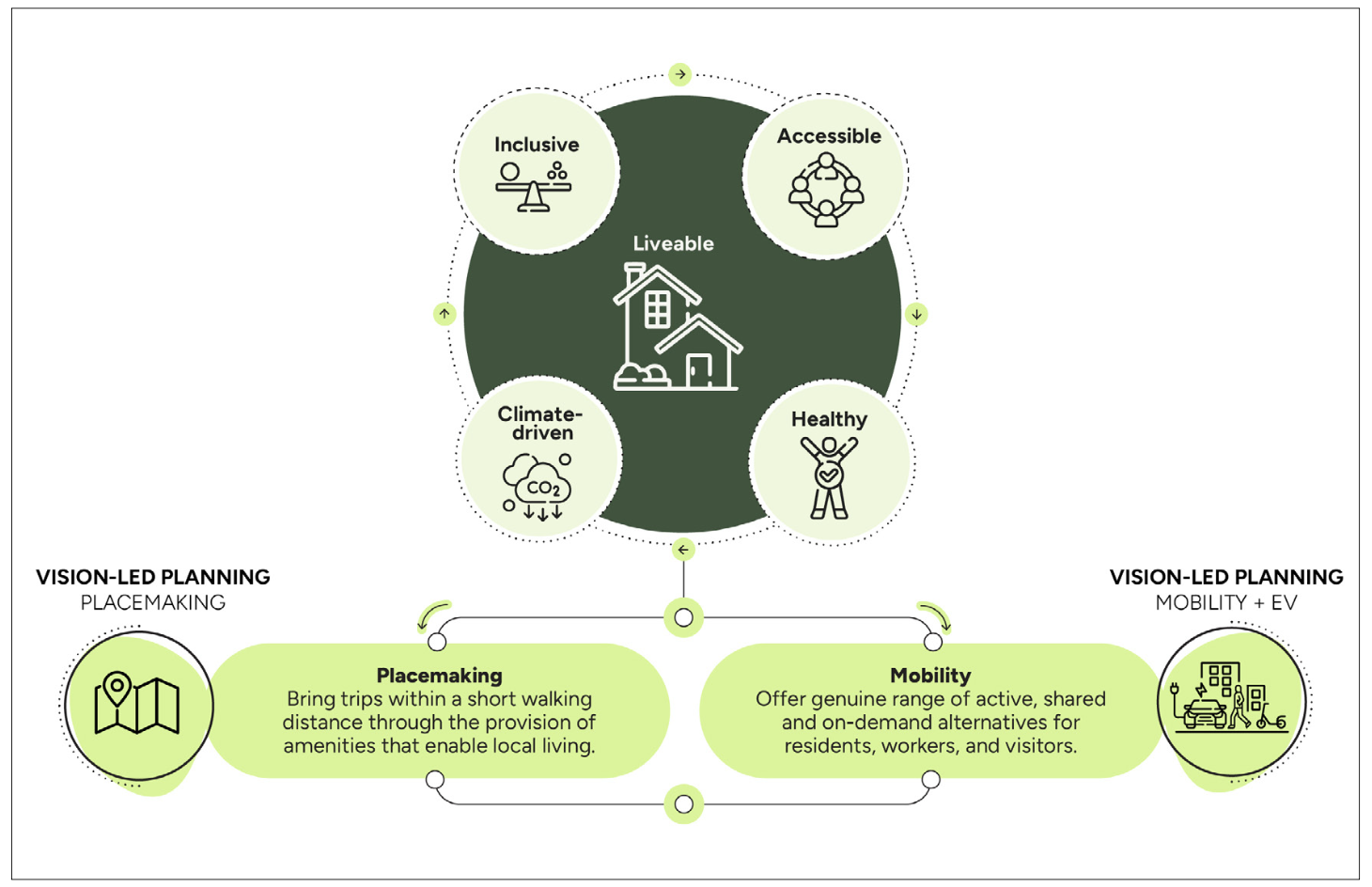
Figure 1 – SLR’s Vision Led Planning Framework
The ultimate aim of any scheme is to deliver liveability. This Framework helps to meet that aim by setting the desired outcomes of Climate-driven, Healthy, Accessible and Inclusive communities. These outcomes are then pursued through a combination of Placemaking and Mobility interventions within the masterplan. (Credit: SLR)
Placemaking interventions
In transport planning terms, it makes obvious sense that before considering mobility solutions for any significant scheme, we must first explore all options in placemaking. By providing green spaces, schools, retail, employment and community facilities within a short walk or cycle, we can remove the reliance on private car trips by offering the freedom to fulfil many daily activities locally, either physically or virtually.
DfT’s Science Advisory Council Paper on “Land use and transport planning” (2024) (Ref 3) recommended that “evidence is needed to show how good planning and design can rise to the challenge of meeting residents’ needs”. We took up this challenge at SLR ‘s Transport Planning R&D team to analyse multiple data sources to provide such evidence to enhance the Masterplanning process.
In this regard Mike Axon, Global Director of Transport at SLR, spoke at the Labour Party Conference about some of the evidence we deploy around local travel behaviour. For example, we already know that on average, in Urban City and Town areas, there is a huge change in travel behaviour once distances increase.
- 25% of trips are under 1 mile and 78% of these are walked.
- 54% of trips are over 2 miles and 85% of these are made by car.
We also know that whether in Urban or Rural areas, 90% of trips under 800m are made by walking.
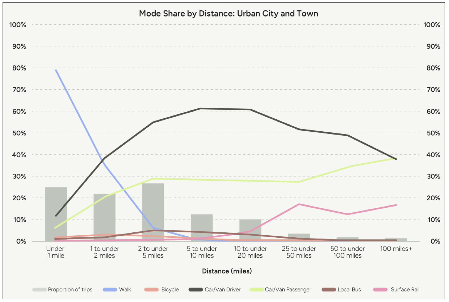
Figure 2 - Mode Share by Distance: Urban City and Town
The diagram shows that under a mile, 80% of trips are made by walking. The car makes up less than 15% of these trips. As trips increase in excess of 2 miles, walking decreases to less than 10%. The highlights not only the importance of placemaking, but the importance of mobility opportunities beyond those trips made immediately local – to be able to break the norm of car driver dominance. (Credit: National Travel Survey 2023)
Overall, across all journeys, in either Urban or Rural areas, 29% of all trips are made by foot (Ref 4). Since this is an average and includes existing infrastructure which is often sub-standard, it is reasonable to expect that this rate can be increased with the closer proximity of amenities and the design of more attractive and direct walking routes.
Techniques that maximise walking mode share must be crucial to delivering ‘Vision-led’ New Towns.
By prioritising placemaking, and embedding walking into day-to-day trips, this provides benefits to health, climate, and wider environmental objectives. It was surely significant that Section 3 of the New Towns Taskforce Report covers entirely Placemaking Principles. The importance of this recognition in the context of transport planning cannot be underestimated.
We also know that for too long, the design of significant schemes has been driven by provision that aims to cater for peak hour trips. But despite the transport planning sector traditionally focusing a lot of analysis on commuting trips, these only make up 14% of trips on a typical weekday in urban city and town areas. National Travel Survey data actually tells us that leisure and education trips comprise more than half of all journeys made.
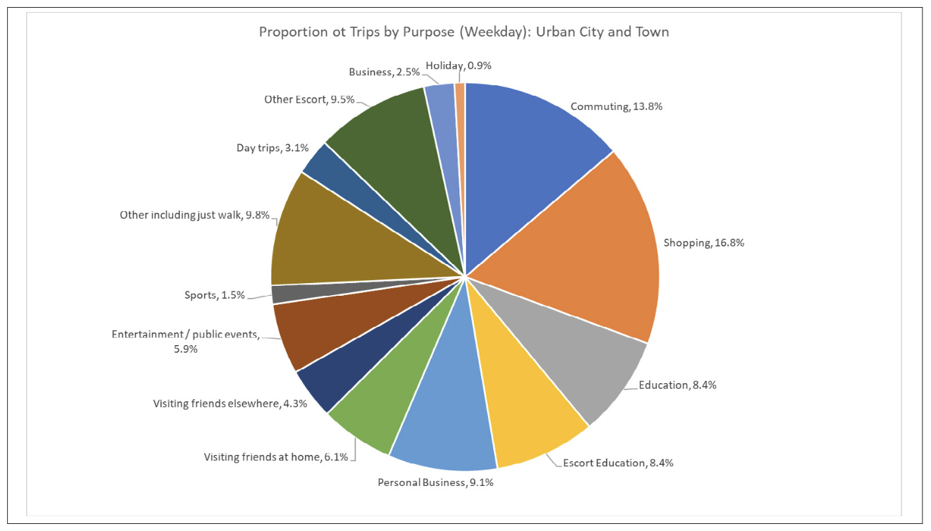
Figure 3 - Journey Purpose Across an Average Weekday
The diagram shows that commuting trips make up only 13.8% of trips across an average weekday – despite the transport planning industry generally giving this the greatest priority. (Credit: National Travel Survey 2023)
Mobility
Once the placemaking components have been fully included in a masterplan design, consideration will then turn to the provision of mobility interventions, for internal and external connections – across all journey purposes. For these trips, the mobility interventions of the vision also need to shift journeys away from private car. We can do this by offering a genuine range of mobility options that make sustainable mobility behaviour the natural first choice for most journey types, and not a barrier due to journey time, duration, or safety.
Such mobility interventions should take the form of:
-
High-quality active travel infrastructure provision;
-
Mass Rapid Transit Options – such as those planned for Milton Keynes;
-
Bus services and Demand Responsive Transport offering convenient on-demand pickups towards external destinations;
-
Shared micro mobility services (bike, e-bike, e-scooter, e-cargo bike);
-
EV charging infrastructure;
-
Mobility Hubs providing convenient access to shared mobility and public transport services; and
-
EV car club and real time app-based carpooling – for when a car is needed. It must be recognised that for a lot of people, access to a car will still be required, for certain journeys at certain times.
A misguided vision
We unfortunately still see many schemes which put forward a vision, but then rush to highways mitigation measures, before the placemaking and sustainable mobility interventions have had the opportunity to change the liveability of an area.
In such cases - a development that passes the so called ‘highway tests’, based on traffic data such as queue length increases, does not mean the Site is sustainable. There is a need to shift the focus instead to questioning whether the development fails the accessibility, equity, climate, health, and quality of place tests.
Properly addressing this embedded conundrum is surely a key question for the promised revised future Transport Assessment guidance from DfT, when it does hopefully soon arrive!
In June, Planning Inspector Sheilah Holden held a webinar (Ref 5) on “What is meant by a sustainable location?”. She reminded the sector that many planning applications list the related amenities in the masterplan or those close to the site. However, such applications often offered little detail about how many people are realistically likely to walk and cycle to them. She said they also often included unrealistic assumptions on how far people are willing to walk or cycle. Her view was that there is a need for more quantitative data, especially relating to the location in question.
A new Tool to support Vision-led Planning
To support this evolution to Vision-led planning, SLR have recently developed a new assessment method to measure how the masterplan can realise the agreed vision. This Vision-led Planning Tool called Flint is designed to support the way in which placemaking and mobility interventions at the design stage can be demonstrated to maximise local living and sustainable mode share in strategic schemes.
The Tool is deployed within the planning process in consultation with local stakeholders at both Local Plan and Outline planning stages. It assesses masterplan scenarios composed of different placemaking and mobility components. The Tool verifies how the vision outcomes can be realised and helps ensure that the transport hierarchy is supported – with active travel at the forefront, followed by other sustainable mobility options, with the private car at the bottom of the hierarchy.
The Vision-led Planning Tool calculates the site design impact on travel demand, modal share, trip internalisation, carbon emissions, air quality and health, forecast to be generated by the mix of local amenities and employment within the development. Outputs are fed into the resulting Transport Assessment.
The effect of enhancing pedestrian access for internal trips to amenities, and options for other supporting sustainable alternatives to car use for remaining internal and external trips, is also measured.
This ensures that from the Masterplanning stages, new communities can be designed in a way which will achieve its vision objectives. This can provide a powerful and consistent narrative about the kind of place that is being created, to stakeholders.
The Tool utilises data and evidence on trip making behaviour and amenity provision, tailored to the local site conditions and context, to give guidance on:
-
Which amenities are likely to be viable within new developments of different sizes;
-
What the effect on trip making behaviour is likely to be if different amenities are included;
-
Which trips will be localised;
-
Levels of hybrid working and online retail; and
-
The impacts of including additional mobility interventions that support low car use for remaining external trips.
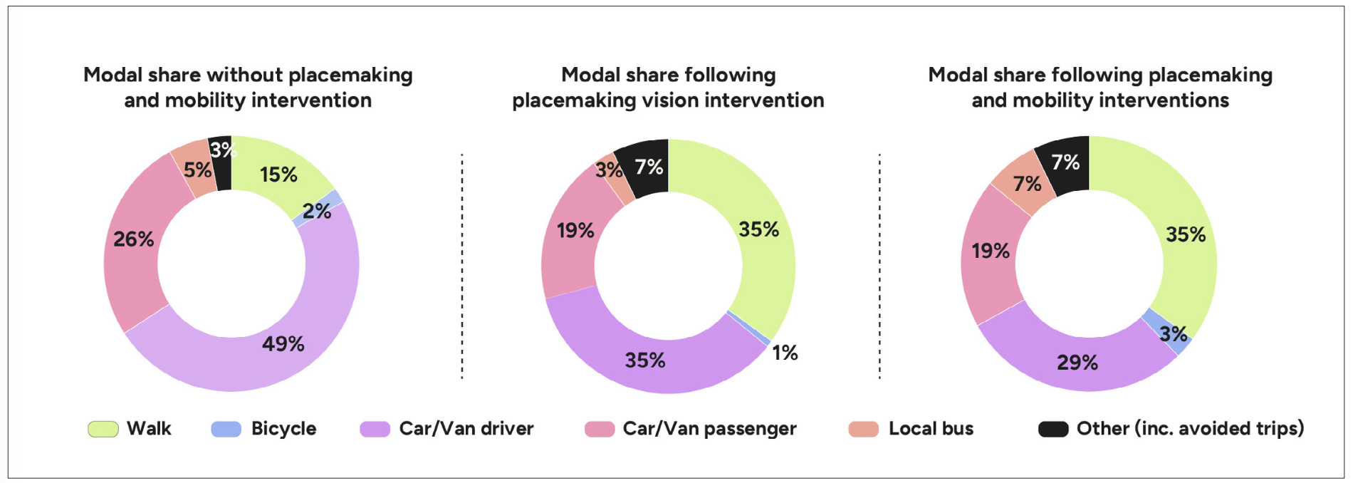
Figure 4 - Illustration of outputs relating to residential generated mode share
These figures relate to an assessment of a strategic mixed-use development and illustrates the impact of placemaking and mobility interventions on modal shares. (Credit: Flint - SLR’s Vision-led Planning Tool)
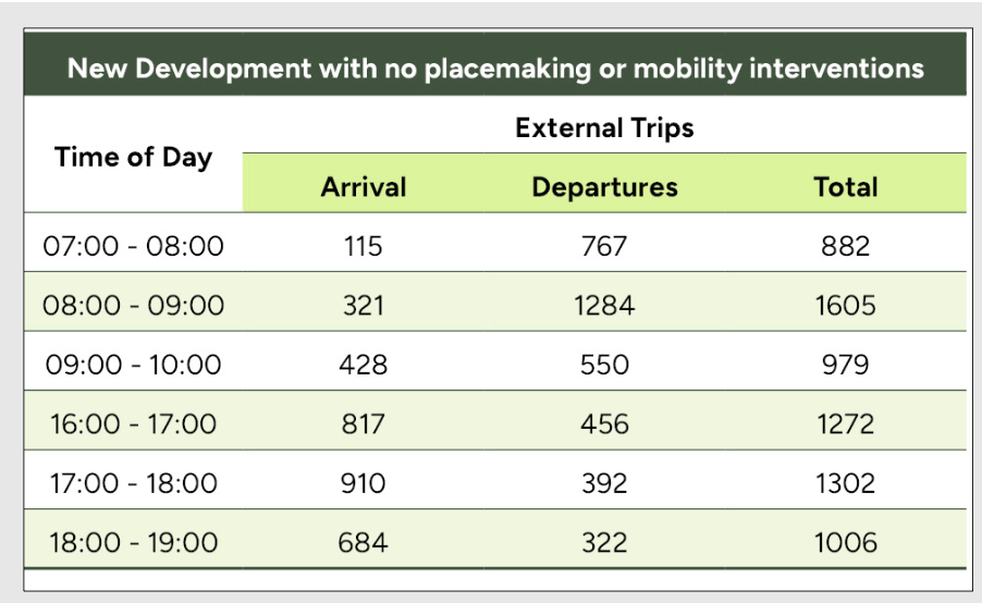
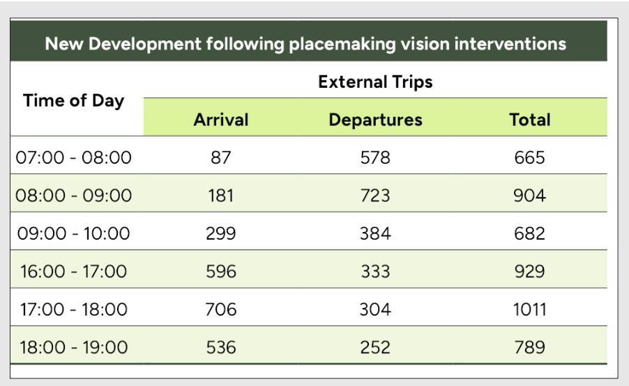
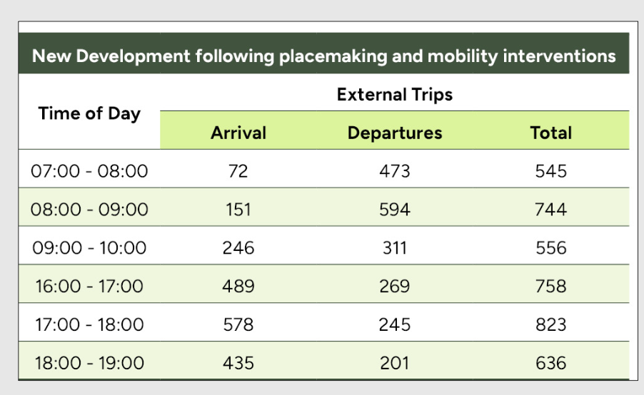
Figure 5 - Illustration of outputs relating to residential generated external car trips
The tables show that the level of external trip generation capable of being reduced through placemaking, and then mobility interventions. For example in the AM peak, for a site of approximately 4,000 dwellings between the hours of 0800-0900, car driver trips could reduce from 1,605 dwellings without any placemaking or mobility interventions, to 904 trips with good placemaking, and 744 trips with sustainable mobility interventions. This is with reference to national travel survey data on how far people travel to facilities and their modal choice.
(Credit: Flint - SLR’s Vision-led Planning Tool, derived from NTS 2023)
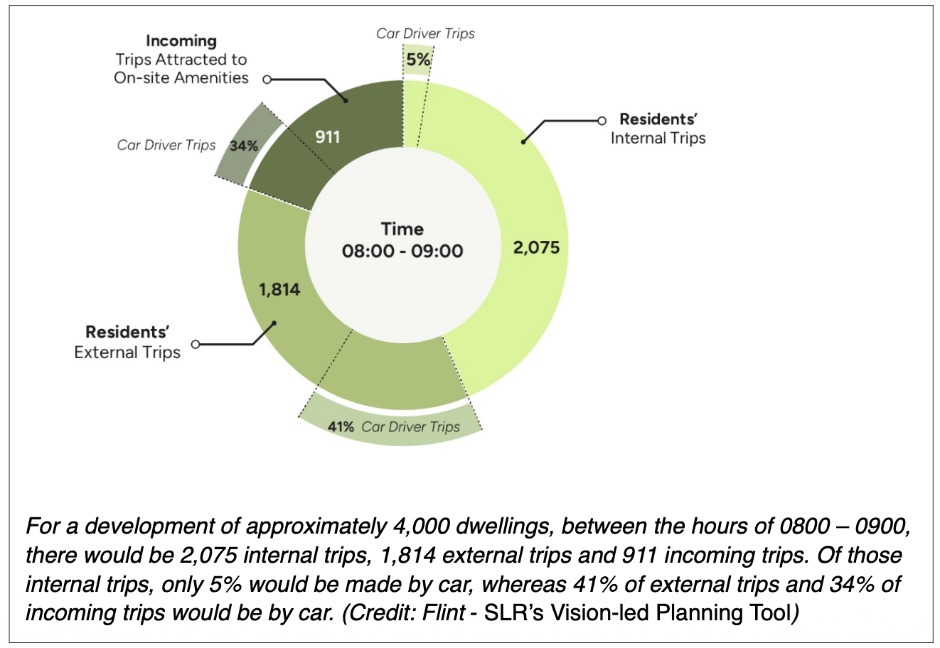
Figure 6 -Example of combined trip generation outputs
We have been deploying the Tool across numerous strategic schemes over the last 2 years at early and advanced stages of the planning process to understand the impact of different combinations of placemaking and mobility components and run comparative scenarios. This proves to be an effective mechanism with which to engage planners, developers and highways officers, and to deliver the scheme’s overall vision. It is therefore helping to bring forward schemes which are more sustainable and in keeping with NPPF objectives.
What can be achieved by the Vision-led Planning Tool?
Despite evolving guidance making it clear that a vision-led approach must be taken, we still see requests to focus on peak hour traffic forecasting to satisfy the ‘highways question’ referred to earlier around ‘worst case scenario’ planning.
This underlines the importance of recognising that transport modelling must consider the estimated change in journey times over the course of the whole day, rather than just at peak hours, to draw more realistic judgements about liveability and the level of transport interventions required. Of course, we need to understand constraints to ensure they can be tackled in the right manner - but any interventions should always be focussed on the same principles that guide placemaking.
For example, for the Pickerings Farm new settlement in Lancashire, on which we have worked, SLR’s microsimulation model concluded that for most of the day, journey times would not significantly change as a result of the development proposals. It did show that for short periods in the commuter peak, journey times would increase, but only by a few minutes.
At inquiry, we were very pleased to find that the Inspector granted planning permission citing that any such impact would be outweighed by the identified benefits of the scheme including the provision of affordable homes, with the application centred around a vision prioritising climate and health objectives. (Ref 6)
In other strategic schemes, we have also successfully argued that packages of amenities and sustainable transport interventions - including mobility hubs – offer substantial mitigation potential and should be considered before pulling the lever of major highways infrastructure.
A positive way forward
Following years of debate over the definition of what is ‘vision-led’, and its implications for the transport planning sector, it is noteworthy that the New Towns Taskforce Report states:
“While the longer-term vision should be clear, each town’s strategic masterplan and design code should allow a degree of flexibility to meet the evolving needs and aspirations of local people. They should be periodically reviewed and updated through genuinely inclusive processes, to foster a sense of ownership and shared commitment between residents and delivery partners. This will help build a successful place and resilient communities.”
In order to make New Towns a success, we therefore need to deploy the vision-led planning approach to design liveable communities based around packages of placemaking and mobility components that are bespoke for particular locations.
In so doing we must show at the planning stages that such designs will have measurable benefits to climate, health, accessibility and inclusivity. We then need to ensure any such mobility strategy is designed to be flexible to adapt in the future.
References:
-
NPPF - National Planning Policy Framework - Guidance - GOV.UK
-
New Towns Taskforce Report to Government New Towns Taskforce: final report
-
DfT’s Science Advisory Council Paper on “Land use and transport planning” (2024) Land use and transport planning: DfT Science Advisory Council paper - GOV.UK
-
National Travel Survey 2024
-
“What is meant by a sustainable location?” Webinar – Sheila Holden Planning Inspectorate webinars - GOV.UK
-
Revised Decision Letter with IR Pickerings Farm Penwortham (APP/F2360/W/22/3295498)
Paul Curtis is Director of Transport and Mobility Research and Development for SLR Consulting.
James Williams is Associate Director Transport & Mobility Planning at SLR Consulting.
This article was first published in LTT magazine, LTT924, 15 October 2025.
You are currently viewing this page as TAPAS Taster user.
To read and make comments on this article you need to register for free as TAPAS Select user and log in.
Log in